355
Pryor MountainHike of chigbuzzards on Pryor Mountain, Little Missouri River, Ouachita National Forest
12/21/19
The morning of the Saturday of the month of December started off with imperfection. The Waffle House that once was there, was now no more. The Ihop up the road was still in existence, and so, became my second option. This was in Hot Springs, as I was heading to the southwest corner of the state. Breakfast was fairly enjoyable. I read the paper and drank some coffee. My personal carafe arrived late, as no coffee was ready immediately. The crowd there at 2:30 a.m. was not too annoying. The waitperson was friendly but had an air of sarcasm about her. She was rewarded appropriately...$3.00 on a $10.00 check. Actually...that was probably a little generous. I moved westward. There was a slight chance of rain this morning, and an occasional mist speckled the windshield of my OTU (Outdoor Transportation Unit), which is a Subaru Crosstrek. This is a manly vehicle to be sure. I feel no need for the common pickup truck so desired by my fellow man. It does all that is required by me. Oh look!...I have arrived.
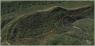
At 5:15 with 38° and a goodly cloud cover, I penetrated the edge and eventually was within the interior of the shrubbery. The slope was immediate. A very light rain, almost sleet, fell as the top was reached. So began my 1.25 mile hike of difficulty. The spine was followed, but much of the time the right side, just down the hill was the easiest path. Neither were good, man. It took more than two hours to cover this ridgeline. The rain was intermittent. When my end was reached, the clouds were parting and my view of the valley was one of wonder. It was viewed for a time. At 9:30 the downward slope was slid down. I remained at an elevation near 1200 feet as the series of angles were traversed with much included hurt. By 11:15, the saddle of hope was utilized for lunch. This was a swale of goodly levelness that provided me with hope for survival. At 12:00 with 50°, my point of origin was in view. What seemed like eight miles was in actuality, a mere four miles. This hike...not recommended. For other hikes in the area go to Blaylock Mountain, Winding Stairs , Blaylock Creek, Little Missouri Falls, Little Missouri Falls again, Eagle Rock Loop (partial) and the Little Missouri Trail.


